


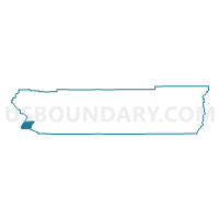
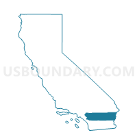
Voting District 10730, Riverside County, California
About
Outline

Summary
| Unique Area Identifier | 537238 |
| Name | Voting District 10730 |
| County | Riverside County |
| State | California |
| Area (square miles) | 56.43 |
| Land Area (square miles) | 56.43 |
| Water Area (square miles) | 0.00 |
| % of Land Area | 100.00 |
| % of Water Area | 0.00 |
| Latitude of the Internal Point | 33.55201460 |
| Longtitude of the Internal Point | -117.41609890 |
Maps

Graphs
Select a template below for downloading or customizing gragh for Voting District 10730, Riverside County, California


Neighbors
Neighoring Voting District (by Name) Neighboring Voting District on the Map
- Voting District 10660, Riverside County, CA
- Voting District 10675, Riverside County, CA
- Voting District 10710, Riverside County, CA
- Voting District 10715, Riverside County, CA
- Voting District 50256, Orange County, CA
- Voting District 50446, Orange County, CA
- Voting District 50462, Orange County, CA
- Voting District 54210, San Diego County, CA
Top 10 Neighboring County Subdivision (by Population) Neighboring County Subdivision on the Map
- Murrieta CCD, Riverside County, CA (282,939)
- Mission Viejo CCD, Orange County, CA (221,910)
- Elsinore Valley CCD, Riverside County, CA (110,544)
- Fallbrook CCD, San Diego County, CA (47,304)
Top 10 Neighboring Place (by Population) Neighboring Place on the Map
Top 10 Neighboring Elementary School District (by Population) Neighboring Elementary School District on the Map
Top 10 Neighboring Secondary School District (by Population) Neighboring Secondary School District on the Map
Top 10 Neighboring Unified School District (by Population) Neighboring Unified School District on the Map
- Capistrano Unified School District, CA (343,291)
- Saddleback Valley Unified School District, CA (205,432)
- Lake Elsinore Unified School District, CA (117,442)
- Murrieta Valley Unified School District, CA (104,527)
Top 10 Neighboring State Legislative District Lower Chamber (by Population) Neighboring State Legislative District Lower Chamber on the Map
Top 10 Neighboring State Legislative District Upper Chamber (by Population) Neighboring State Legislative District Upper Chamber on the Map
- State Senate District 36, CA (1,036,001)
- State Senate District 38, CA (973,002)
- State Senate District 33, CA (936,082)
Top 10 Neighboring 111th Congressional District (by Population) Neighboring 111th Congressional District on the Map
Top 10 Neighboring Census Tract (by Population) Neighboring Census Tract on the Map
- Census Tract 320.23, Orange County, CA (13,544)
- Census Tract 190.01, San Diego County, CA (5,946)
- Census Tract 432.72, Riverside County, CA (4,976)
- Census Tract 464.01, Riverside County, CA (3,768)